
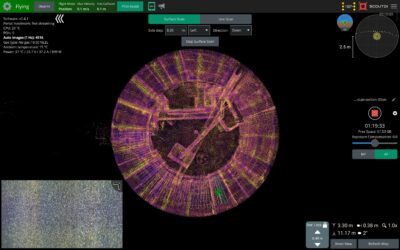
One hour and nineteen minutes into an inspection, the counter read 4,516 images. On screen, a rotated point cloud showed the tank from above: roughly two-thirds of the sector already scanned, a light blue path tracing what was left. Nothing here was a replay or post-processing, this was the live...
News feed
Multiple Inspection Tasks. One Flight. Ultrasonic Thickness Measurement is only as good as the surface it’s taken from. That’s the boring truth everyone in NDT knows and too many workflows quietly work around. One continuous, controlled UTM workflow With the Scout 137 Gen 3...

Two questions often come up when we talk to security-minded customers. Here is how Scout 137 and the Scout Portal answer them. A physical tether carries both power and data, forming a fully wired path between drone and operator. Customers evaluating Scout 137 regularly raise two...
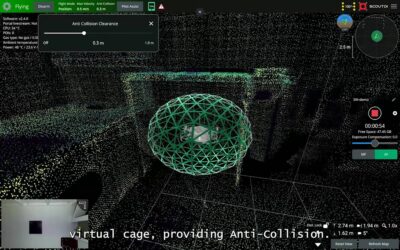
One of the key additions in Software Version 2.4.0 is Virtual Cage, a new anti-collision feature designed to make confined-space drone operations safer and easier. Unlike traditional anti-collision systems that rely only on what the LiDAR can see at any given moment, our Virtual Cage uses the...
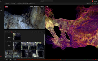
High-density 3D LiDAR mapping at Cleveland Tin Projects, capturing underground workings safely and without human entry. Executive Summary Survey contractor: Southern Lidar Sales partner: Chironix (Australia) Location: Northwestern Tasmania Mine depth: > 400...

Safer turbine foundation inspections with better documentation Executive Summary Ørsted introduced ScoutDI’s tethered drone system for offshore wind turbine foundation inspections. The shift has supported safer inspection practices by reducing the need for confined...